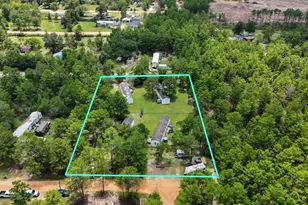
Full Property Details for Parcel B Adams Dr
General
- Price: $355,894
- Taxes: $54 (2024)
- Status: Active
- Type: Agricultural Land
- Source: Emerald_Coast
- MLS ID: 977998
- Updated: 4/13/2026
- Added to Site: 320 day(s) ago
Location
- Area: 23 - North Walton County
- County: Walton
- Subdivision: METES & BOUNDS
- Driving Directions: From DeFuniak Springs at the intersection of Hwy 90 and US Hwy 331 N, follow 331 N 10 miles. Turn right onto Hwy 2-E for 4.4 miles, turn left onto Co Hwy 0605, go 2.8 miles and take a slight right onto Adams Dr., follow through stop sign, property begins on the right at the pasture. Corner is flagged. FOLLOW THESE DIRECTIONS. DO NOT RELY ON A GPS.
School Information
- Elementary School: Paxton
- Middle School: Paxton
- High School: Paxton
Utilities
- Utility Description: Electric, Phone
Structural Information
- Current Bldg. Use: Pasture
Lot Features
- Lot Size (Acres): 46.22
- Lot Size (Sq. Ft.): 2,013,343.2
- Lot Dimensions: 1658.11 x 910.77 x 1340.12 x 1322.16
- Frontage: County Road
- Street/Road Desc.: Paved Road
- Lot Features: Interior, Level, Survey Available
- Zoning: Agriculture, County, Horses Allowed
Financial Considerations
- Price Per Acre: $7,700
- Tax Amount: $54.04
- Tax Year: 2024
Disclosures and Reports
- Legal Description: COM SE/C SE 1/4 NE 1/4 SEC 10-5N-20W FOR POB; N 88 DEG 32'05''W 1322.16 FT, N88 DEG 33'13''W 420.57 FT TO E ROW LN ADAMS DR, N 10 DEG 40'05''E ALG ROW 390.29 FT TO A CURVE WITH RAD 2254.67 FT WITH CB AND D N 19 DEG 59'11''E 434.29 FT, ALG SAID CURVE ARC 434.97 FT TO A CURVE WITH RAD 680.74 FT WITH CB AND D N 40 DEG 45'49''E 347.52 FT, ALG SAID CURVE ARC 351.41 FT, N 56 DEG 57' 59''E 481.44 FT, DEP
- APN: 10-5N-20-30000-009-0000
- Property ID: 10-5N-20-30000-009-0000
Listed by Merrifield & Pilcher Realty