This is a carousel with tiles that activate property listing cards. Use the previous and next buttons to navigate.
1/1
$7,000
This is a carousel with tiles that activate property listing cards. Use the previous and next buttons to navigate.
1/1
Property Description
Large lot in area of great potential. Estimated time currently for Activity center 6 is 8-10 years. North Port has completed several activity centers with great success. Lot located in " The Shire" Activity number 6 of economic development North Port Activity Center #6 "The Shire" Quick Facts : Activity Center #6 is located in the southeastern section of the City of North Port and extends north to the Snover Waterway, south to the Newman Waterway, east to Yorkshire St., and west to Price Blvd. Activity Center #6 is in an excellent spatial location as the I-75 freeway passes directly through and it is in proximity to other existing amenities within the City of North Port. Several waterways run directly through Activity Center #6 including the Newman Waterway, the Cocoplum Waterway, the Amnesty Waterway, the Bethlehem Waterway, and the Littlefield Waterway. The City of North Port is working with the Federal Highway Administration (FHWA) in exploring the potential for a freeway interchange onto I-75 within Activity Center #6, bringing enhanced connectivity to the area. The vast majority of Activity Center #6 remains undeveloped which opens the possibility for new developments and projects to this area within the City of North Port. According to the City of North Port Code, "This Activity Center shall be established to provide for commercial, industrial and residential uses," (Sec. 55-40). Permitted land uses include: Medium and High Density Residential, Professional Office, Commercial, Industrial, Public Recreation Open Space, and Utility Industrial Corridor uses. The City of North Port Planning Department is currently in the process of formulating a Master Plan for Activity Center #6 which will look into various practices and procedures to revitalize the area and facilitate successful growth and development patterns. Currently not in scrub jay.
Full Property Details
Full Property Details for Sheno Dr
General
- Sold For: $7,000
- Taxes: $357 (2024)
- Status: Closed
- Type: Lots/Land
- Source: MidFloridaRegionalMLS
- MLS ID: C7510306
- Added to Site: 286 day(s) ago
Location
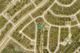
- Area: 34288 - North Port
- County: Sarasota
- Development Name: 34288 - North Port
- Subdivision: PORT CHARLOTTE SUB 44
- Driving Directions: Yorkshire north to right on Patriot and left on Sheno
Community
- Community Name: 34288 - North Port
Utilities
- Sewer: None, Septic Needed
- Water: None, Well Required
- Utility Description: Electrical Nearby, Other
Structural Information
- Current Bldg. Use: Residential
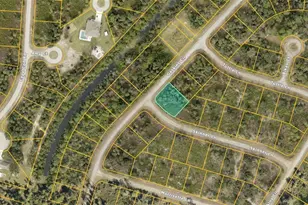
Lot Features
- Lot Size (Acres): 0.32
- Lot Size (Sq. Ft.): 14,016
- Lot Size: 14016
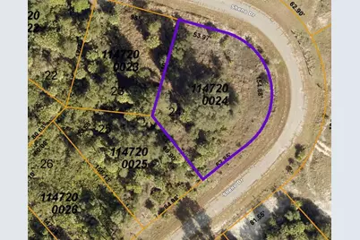
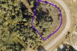
- Lot Dimensions: 158 x 54 x 110 x 90 x 62
- Street/Road Desc.: Paved
Financial Considerations
- Price Per Acre: $21,875
- Tax Amount: $357.06
- Tax Year: 2024
Disclosures and Reports
- Ownership: Fee Simple
- Special Conditions: None
- Legal Description: LOT 24 BLK 2000 44TH ADD TO PORT CHARLOTTE
- Flood Zone Info: X
- APN: 1147200024
- Property ID: 1147200024
- Block/Lot/Section: 2000
Listed by Re/Max Palm Realty
Sold by Re/Max Alliance Group
Get Pre-Approved Today
Price & Sales History for Sheno Dr
Date
Details
Price
Change
Source
1/28/2026
Sold
$7,000
-36.36%
MLS
11/18/2025
Price Reduced
$11,000
-26.67%
MLS
5/22/2025
Listed
$15,000
—
MLS
Disclaimer: Historical sales information is derived from public records provided by the county offices. Information is not guaranteed and should be independently verified.
Sheno Drive, North Port, FL 34288 (MLS# C7510306) is a Lots/Land property that was sold at $7,000 on January 28, 2026. Want to learn more about Sheno Drive? Do you have questions about finding other Lots/Land real estate for sale in North Port? You can browse all North Port real estate or contact a Coldwell Banker agent to request more information.

