This is a carousel with tiles that activate property listing cards. Use the previous and next buttons to navigate.
1/31
$169,900
This is a carousel with tiles that activate property listing cards. Use the previous and next buttons to navigate.
1/31
Property Description
Tucked away on 14 breathtaking acres, once part of the legendary Sandlyland concert venue, this isn't just land - it's a place that's been lived on, loved, and worked. Our family cut hay here, raised chickens and hogs, and walked the woods where deer, rabbits, and turkeys still wander. There's a 5-acre hay field, brand new pastures for horses and pigs, and several freshly cleared acres just waiting for what's next. It's peaceful - surrounded by large parcels, including 70+ acres owned by the church next door, with trails and even a disc golf course. This land has been part of our home, our memories, and our everyday life. Now, it's ready for yours. Build a homestead, grow your roots, or simply breathe. It's more than property - it's potential, history, and a fresh start.
Full Property Details
Full Property Details for V/L E M-79 Hwy
General
- Price: $169,900
- Taxes: $387
- Status: Active
- Type: Acreage
- Source: SWMRIC_MLS
- MLS ID: 25027809
- Updated: 8/23/2025
- Added to Site: 221 day(s) ago
Location
- Area: Grand Rapids - G
- County: Barry
- Cross Streets: M-66 / SWIFT RD
- Driving Directions: From Grand Rapids, M-37 S , turn right onto Green St. Right onto M-37 S/S Hanover St, Left onto M-79 E. Land is between Grace Community Church and Daniels Funeral Home.
Utilities
- Utility Description: Electricity Available, Phone Available, None
Lot Features
- Lot Size (Acres): 14.12
- Lot Size (Sq. Ft.): 615,067
- Lot Dimensions: 819 x 626 x 1058 x 663
- Frontage: Paved
- Lot Features: Level, Buildable, Cleared, Recreational, Tillable
- Zoning: AG
Financial Considerations
- Tax Amount: $387.42
- Terms: Cash, Conventional
Disclosures and Reports
- Legal Description: THAT PART OF THE SOUTHWEST QUARTER OF SECTION 35. TOWNSHIP 3 NORTH, RANGE 7 WEST, CASTLETON TOWNSHIP, BARRY COUNTY, MICHIGAN, DESCRIBED AS: BEGINNING AT A POINT ON THE WEST LINE OF SAID SECTION 35 THAT IS NORTH 0051'54'' EAST 1235.03 FEET OF THE SOUTH WEST CORNER OF SAID SECTION 35; THENCE CONTINUING NORTH 0051'54'' EAST ON THE WEST LINE OF SAID SECTION 35 A DISTANCE OF 1058.93 FEET TO THE CENTERL
- Property ID: 05-035-010-20
Listed by Five Star Real Estate (Hastings), Chase A Coughlin
Get Pre-Approved Today
Get a Great Insurance Rate
Price & Sales History for V/L E M-79 Hwy
Date
Details
Price
Change
Source
6/11/2025
Listed
$169,900
—
MLS
Disclaimer: Historical sales information is derived from public records provided by the county offices. Information is not guaranteed and should be independently verified.
Tax History
Tax History for V/L E M-79 Hwy
Year
Property Taxes
Change
Tax Assessment
Change
2023
$186
—
$27,400
7%
2023
$186
8%
$25,600
27%
2018
$172
—
$20,200
7%
2018
$172
—
$18,900
11%
2018
$172
—
$17,000
-2%
2018
$172
100%
$17,400
12%
2017
—
$15,600
—
Disclaimer: Historical tax information is derived from public records provided by the county offices. Information is not guaranteed and should be independently verified.
Estimate the Cost
Estimate the Cost for V/L E M-79 Hwy
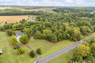
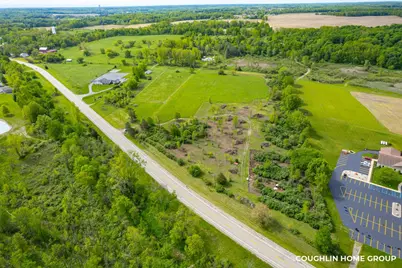
V/L E M-79 Highway, Nashville, MI 49073 (MLS# 25027809) is a Acreage property with a lot size of 14.12 acres. V/L E M-79 Highway is currently listed for $169,900 and was received on June 11, 2025. Want to learn more about V/L E M-79 Highway? Do you have questions about finding other Acreage real estate for sale in Nashville? You can browse all Nashville real estate or contact a Coldwell Banker agent to request more information.

